Extraordinary
Planning and Consultation Committee Agenda 17
December 2024
5. Officers’
reports
Item: Planning
Matter
Distribution: Public
Manager: Frank
Vassilacos, Director Planning, Environment and Strategy
Author: Renae
Ahern, Manager Planning and Environmental Health
Application
summary
|
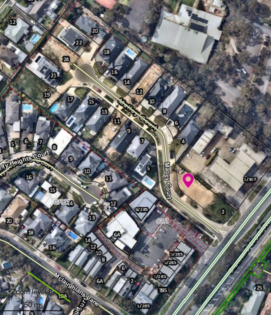
Address
of the land
|
2
Malley Court, Plenty
|
|
Site
area
|
913.5
m2
|
|
Proposal
|
Building
and works to construct four (4) shops
|
|
Application
number
|
86/2024/06P
|
|
Date lodged
|
9 February 2024
|
|
Applicant
|
Permits Hub
|
|
Zoning
|
Commercial 1 Zone
|
|
Overlay(s)
|
Design Development
Overlay (Schedule 4)
|
|
Reason for being
reported
|
Called in by Ward
Councillor.
|
|
Number of objections
|
11
|
|
Key issues
|
· Strategic
location
· Business
and economic development
· Built
form and landscaping
· Car
parking and traffic
· Waste
management
· Vegetation
impacts
|
Location map
|
That the Committee (under delegation from Council) issue a
Notice of Decision to Grant a Permit to the land located at 2 Malley Court,
Plenty, for Building and works to construct four (4) shops, in accordance
with the submitted plans and subject to the following conditions:
1. Before the development commences, amended plans to the satisfaction of
the Responsible Authority must be submitted to and approved by the
Responsible Authority. When approved, the plans will be endorsed and will
then form part of this permit. The plans must be generally in accordance with
the plans submitted with the application but modified to show:
a) All four buildings setback 3
metres from the north-east title boundary. The setback must comprise a 0.8
metre wide bin storage area, a 1 metre wide pedestrian path and a 1.2 metre
wide landscaped area.
b) Wayfinding signage to direct
pedestrians from the car park to the front entry of the shops.
c) Wheel stops to all car spaces
to guide vehicle positioning.
d) The section of footpath on the
south side of car space 11 and 12 deleted and replaced with nature strip.
e) A gate or bollards at the
entrance to the car park to prevent unauthorised vehicle access afterhours.
f) The indicative shop
signage (shown in red on sheet TPA03) deleted from the plans.
g) An amended Landscape Plan to reflect
the changes to the plans required under condition 1 a) and in accordance with
condition 3 of this permit.
h) A Tree Protection Management
Plan in accordance with condition 6 of this permit.
i) An amended Waste
Management Plan to reflect the changes to the plans required under condition
1 a) and in accordance with condition 12 of this permit.
2. The
development as shown on the endorsed plans must not be altered unless with
the prior written consent of the Responsible Authority.
3. Before
the development commences, a landscape plan to the satisfaction of the
Responsible Authority must be submitted to and approved by the Responsible
Authority. When approved, the plan will be endorsed and will then form
part of this permit. The plan must show:
a) A
survey of all existing vegetation and natural features;
b) The
area or areas set aside for landscaping;
c) A
schedule of all proposed trees, shrubs/small trees and ground cover. This
schedule shall include a mixture of selected vegetation from the Council
document ‘Live Local Plant Local’ showing the botanical and
common name of each plant, the quantity to be planted, the pot size and
spacing;
d) The
location of each species to be planted and the location of all areas to be
covered by grass, lawn or other surface material;
e) Paving,
retaining walls, fence design details and other landscape works including
areas of cut and fill;
f) Appropriate
irrigation systems; and
g) Appropriate
maintenance details.
4. Unless
with the prior written consent of the Responsible Authority, before the occupation of the development, the landscaping
works shown on the endorsed plans must be carried out, completed and
maintained to the satisfaction of the Responsible Authority.
5. No
vegetation on-site (unless specified on the endorsed plans) shall be removed,
destroyed, felled, lopped, ringbarked, uprooted or otherwise damaged except
with the prior written consent of the Responsible Authority.
6. Before
the development commences, a Tree Protection Management Plan to the satisfaction
of the Responsible Authority must be submitted to and approved by the
Responsible Authority. When approved the plan will form part of this permit.
The plan must show:
a) The
paving tiles within the TPZ of Tree 9 must be laid at grade with no excavation
and have gaps between to allow water to penetrate down to the root system.
b) There
must be no excavation within the SRZ of Tree 9.
c) There
must be no fill within the SRZ area of Tree 9.
d) The
works for the building footprint within the TPZ of Tree 9 must be supervised
by a qualified arborist to determine quantity and size of roots cut and to
ensure roots are pruned cleanly. This will determine whether any mulching or
extra irrigation is required.
e) Ground
protection must be laid within the SRZ of Tree 9. This must consist of a
layer of geofabric with 100 mm of mulch on top and then rigid boards.
f) No
underground services are to be installed within the TPZ of Tree 9.
g) Following
TPZ set up with fences and ground protection, the Relevant Authority must
inspect the site to ensure the trees are protected prior to works commencing.
h) Any
pruning required must be minimum in nature and carried out by qualified
arborists conforming to AS 4373-2007.
7. Prior
to development commencing (including any demolition, excavations, tree
removal, delivery of building/construction materials and/or temporary
buildings), the trees marked on the endorsed plans as being retained must
have a Tree Protection Fence (TPF) to the satisfaction of the Responsible Authority.
The fencing associated with this TPZs must meet the following requirements:
a) Extent
The tree protection fencing (TPF) is to be provided to
the extent of the TPZ, calculated as being a radius of 12 x Diameter at
Breast Height (DBH – measured at 1.4 metres above ground level as
defined by the Australian Standard AS 4970.2009)
Fencing may be reduced directly adjacent to the works
area only to allow access during construction (i.e. no more than 1 metre away
from the works/ construction area)
b) Fencing
All tree protection fencing required by this permit must
be erected in accordance with the approved TPZ.
The TPF must be erected to form a visual and physical
barrier and must be a minimum height of 1.5 metres and of chain mesh or
similar fence
c) Signage
Fixed
signs are to be provided on all visible sides of the TPF clearly stating
“Tree Protection Zone – No Entry”, to the satisfaction of
the Responsible Authority.
d) Provision
of Services
Unless
with the prior written consent of the Responsible Authority, all services
(including water, electricity, gas and telephone) must be installed underground,
and located outside of any TPZ, to the satisfaction of the Responsible
Authority.
e) Access
to TPZ
Should
temporary access be necessary within the Tree Protection Zone during the
period of construction, the Responsible Authority must be informed prior to
relocating the fence (as it may be necessary to undertake additional root
protection measures such as bridging over with timber).
8. Prior
to the commencement of the approved works (including any demolition,
excavations, tree removal, delivery of building/construction materials and/or
temporary buildings), the erected tree protection fences must be inspected
and approved by the Responsible Authority.
Once erected to the required
standard, the tree protection fencing shall be maintained in good condition
and may only be removed upon completion of all development works, to the
satisfaction of the Responsible Authority.
9. The
following actions must not be undertaken in any tree protection zone as
identified in this permit, to the satisfaction of the Responsible Authority:
a)
Materials or equipment stored within
the zone;
b)
Servicing and refuelling of equipment
and vehicles;
c)
Storage of fuel, oil dumps or
chemicals;
d)
Attachment of any device to any tree
(including temporary service wires, nails, screws or any other fixing
device);
e)
Open cut trenching or excavation
works (whether or not for laying of services);
f)
Changes to the soil grade level;
g)
Temporary buildings and works; and
h)
Unauthorised entry by any person, vehicle or machinery.
10. The
materials to be used in the construction of the buildings and works hereby
permitted shall be of non-reflective type and finished in muted tones, to the
satisfaction of the Responsible Authority.
11. Air-conditioning
and other plant and equipment installed on the subject buildings shall be so
positioned and baffled so that noise disturbance is minimised, to the
satisfaction of the Responsible Authority.
12. Prior
to the development commencing, a Waste Management Plan to the satisfaction of
the Responsible Authority must be submitted to and approved by the
Responsible Authority. When approved, the plan will be endorsed as
evidence of its approval. The plan must specify:
a) The
details and location of bin storage and bin collection points by a private
waste contractor (if not a Council collection).
b) Access
route and method of access for the vehicles collecting waste.
c) Details
and location of bin storage areas for each approved dwelling.
d) Odour
control from bin storage areas.
13. A
minimum of 13 car spaces must be provided and maintained on the land for the
development hereby permitted, to the satisfaction of the Responsible
Authority.
14. Before
the occupation of the development, the areas set aside for the parking of
vehicles and access lanes as shown on the endorsed plans must be:
a) Constructed;
b) Properly
formed to such levels that they can be used in accordance with the plans;
c) Surfaced
with an all-weather sealcoat or treated to the satisfaction of the
Responsible Authority to prevent dust and gravel being emitted from the site;
d) Drained
and maintained;
e) Line
marked to indicate each car space and all access lanes;
f) Clearly
marked to show the direction of traffic along access lanes and driveways;
g) All
car spaces installed with wheel stops to guide vehicle positioning;
h) Wayfinding
signage to direct pedestrians from the car park to the shops;
i) A gate or bollards at the entrance to the car park to
prevent unauthorised vehicle access afterhours.
to the satisfaction of the
Responsible Authority. Car spaces, access lanes and driveways must be kept
available for these purposes at all times, to the satisfaction of the
Responsible Authority.
15. The
loading and unloading of goods from vehicles must only be carried out on the
land and must not disrupt the circulation and parking of vehicles on the
land, to the satisfaction of the Responsible Authority.
16. Stormwater
must not be discharged from the subject land other than by means of an
underground pipe drain to the nominated point of stormwater discharge. The
nominated point of stormwater discharge is Council underground drainage
system in the front of the property.
17. Vehicular
access and egress to the development site from the roadway must be by way of a
vehicle crossing constructed to the requirements of the Responsible
Authority, to suit the proposed driveway and the vehicles that will use the
crossing. The Responsible Authority must approve the location, design
and construction of the crossing. Any existing unused crossing must be
removed and the disturbed area reinstated to the satisfaction of the
Responsible Authority. All vehicle crossing works are to be carried out
with Council supervision under an Infrastructure Works Permit.
The width of the driveway at
property boundary must match the width of the vehicle crossing.
The vehicle crossing must comply
to “Vehicle Crossing Policy” Version 1.1 August 2014 and to
Standard Drawing (NS3000, NS3010, NS3020, NS3021 or NS3030 and NS3031) unless
written approval has been granted from Council’s Infrastructure Unit.
Vehicle crossing near other
services assets may require permission from the relevant authority.
18. No
polluted stormwater, effluent and/or sediment laden runoff from the
development site is to be discharged directly or indirectly into
Council’s drains, Melbourne Water’s drains or watercourses or
adjoining private property during any stage of the construction.
Sediment fencing and/or pollution/litter traps must be installed on site and
serviced accordingly to the satisfaction of the Responsible Authority.
19. Driveways,
access lanes, and areas set aside for the parking and access of vehicles must
be constructed and formed to such levels to ensure they can be utilised at
all times and in accordance with the endorsed plans. Car parking must be
line-marked or provided with some other adequate means of showing the car
parking spaces. All must be drained and constructed in concrete, asphalt or
similar surface, and must be carried out and maintained to the satisfaction
of the Responsible Authority.
20. A
footpath in concrete to Council Standards must be constructed from Diamond
Creek Road to the access to the development at the owner’s cost.
21. The
nature strip tree to be removed to accommodate the vehicle crossing must be
replaced at the owner’s cost.
22. This
permit will expire if one of the following circumstances applies:
a) The
development is not commenced within 2 years of the date of this permit.
b) The
development is not completed within 4 years of the date of this permit.
The Responsible Authority may extend the periods referred
to if a request is made in writing before the permit expires, or within 6
months afterwards if the development has not commenced, or 12 months after if
the development has commenced but is not yet completed.
|
Attachments
|
1 . .
|
Development plans
|
|
2.
|
Landscape plans
|
Subject site and surrounds
1. The key features of the
subject land and surrounds are as follows:
· The
site is located at the north side of Malley court and is at the corner of
Diamond Creek Road.
· The
land has an area of 913.5 m2 and is irregular in shape.
· The
land has a gentle fall from west to east.
· The
site does not contain any trees.
· Malley
Court is accessed via a slip lane from Diamond Creek Road.
· There
is a Section 173 Agreement on title that has owner obligations relating to tree
protection and boundary fencing. The proposal would not breach the owner
obligations.
2. The land surrounding the
subject is as follows:
· North
– 307 Diamond Creek Road, Caltex Fuel Station.
· South
– 285 Diamond Creek Road, Commercial development.
· East
– Diamond Creek Road.
· West
– Dwellings addressing Malley Court.
Details of proposal
3. Refer to the attached
plans.
4. Key features of the
proposal include:
· Construction
of four, single storey shops with a combined floor area of 300.9 m2.
· At
grade car park on the west side of the shops, comprising 13 car spaces.
· A
9 metre building setback to Diamond Creek Road and a 2 metre setback to the
north and south boundaries.
· Landscaping
within the front setback, side setbacks and adjacent to the carpark.
· Vehicle
and pedestrian access from Malley Court.
· Active
shop frontages to both Diamond Creek Road to the east and Malley Court to the
south
Planning history
5. Planning application No.
816/2022/06P proposed to construct a two storey building comprising of shops
and offices, but was withdrawn.
6. Planning Application No. 1073/2022/06P was refused on 1 March 2024
for building and works to construct a building comprising four shops, one
office and associated basement car park.
Planning controls
Zoning
7. Pursuant to the Nillumbik
Planning Scheme, the subject site is zoned Commercial 1 Zone (C1Z). Under the zone, a permit is required for building and works. However,
a planning permit is not required for use of the land as a shop.
Overlays
8. The subject land is zoned
Design and Development Overlay (Schedule 4) (DDO4). Under the overlay, a permit
is required for building and works.
Particular provisions
9. Clause 52.06 (Car
Parking) applies to the application. This clause seeks to ensure there is the
provision of an appropriate number of car parking spaces; that car parking does
not adversely affect the amenity of the locality; and that the design and
location of car parking is of a high standard, creates a safe environment for
users and enables easy and efficient use.
10. Clause 65 (Decision Guidelines)
outlines general decision guidelines that must be considered when assessing an
application. These guidelines include the purpose of the zone or other
provision, the orderly planning of the area, and the effect on the amenity of
the area.
Relevant planning policies
11. The Planning Policy Framework
relevant to this application includes:
· Clause
11.01-1S (Settlement)
· Clause
11.02-1S (Supply of urban land)
· Clause
11.03-1S (Activity centres)
· Clause
11.03-1R (Activity centres in Nillumbik)
· Clause
11.03-1L-01 (Activity centres in Nillumbik)
· Clause
15.01-1S (Urban design)
· Clause
15.01-1R (Urban design – Metropolitan Melbourne)
· Clause
15.01-2S (Building design)
· Clause
15.01-2L-01 (Building design in Nillumbik)
· Clause
15.01-4S (Healthy neighbourhoods)
· Clause
15.01-4R (Healthy neighbourhoods – Metropolitan Melbourne)
· Clause
15.01-5S (Neighbourhood character)
· Clause
17.02-1S (Business)
· Clause
17.02-1L (Business in Nillumbik)
Advertising
12. The application has been advertised
by way of posting notices to the owners and occupiers of neighbouring
properties and the erection of two notice boards on-site, one to each street
frontage.
Objections
13. As a result of advertising, a total
of 11 objections have been received. These objections can be summarised as
follows:
· Car
parking and traffic.
· Amenity
impacts from commercial interface with residential street and potential hours
of operation of commercial uses.
· Development
would block line of sight to service station signage.
Planning application
conference
14. A planning application conference
was held on 23 October 2024. The above issues were discussed at length, and
whilst no agreements were achieved, the position of all parties was clarified.
Referrals
Internal
15. The application was referred to
various business units or individuals within Council for advice on particular
matters. The following is a summary of the relevant advice:
|
Council Unit
|
Comments
|
|
Strategic Planning Team
|
The
proposal is consistent with the purposes of the Commercial 1 Zone to provide
for commercial land use and development and Clause 17.02-1L (Business in
Nillumbik) supporting limited local convenience.
|
|
Economic Development and Tourism Team
|
Supportive
of the proposal given that the land is earmarked for commercial purposes and
intensified commercial use and development is encouraged at the site given
its zoning, immediate surrounds and its exposure to an arterial road.
|
|
Traffic and Transport Team
|
The
proposed car parking and vehicle movements are satisfactory.
|
|
Urban Design
|
Advice
provided recommended increasing the north and south boundary setback and that
the footpath should be continuous along the entire Malley Court frontage and
connect to the footpath along Diamond Creek Road. Comments made about the
visual dominance of the car park.
|
|
Infrastructure Development Team
|
No
concerns subject to standard drainage conditions.
|
|
Waste Management Team
|
Private
waste collection is proposed. The Waste Management Plan is satisfactory with
the exception that there is limited space on the north side of the building
to store and transport the bins. A minimum of width of 700 mm is required to
store the bins plus a 1 metre wide pathway for pedestrian access and to
transport the bins.
|
|
Building Services
|
A
building permit is required.
|
|
Council’s Consulting Arborist
|
Third
party Tree no. 9 is a tolerant species and will remain viable subject to tree
protection measures.
It
is proposed to remove Tree no. 10 which is a juvenile specimen planted in
recent years and is owned by Council. This tree can be appropriately replaced
in the landscape.
|
|
Parks and Open Space Team
|
No
objection to the removal of Tree no. 10 subject to replacement planting and
tree protection measures for the remaining trees within the nature strip.
|
External
16. There are no external referral
authorities relevant to this application.
Planning assessment
Introduction
17. The following have been identified
as the key planning issues in relation to the assessment of this planning
application:
· Strategic
location.
· Business
and economic development.
· Built
form and landscaping.
· Car
parking and traffic.
· Waste
management.
· Vegetation
impacts.
18. Assessment of these issues, together
with a response to objections received, will be discussed in the remainder of
this report.
Strategic location
19. The site is zoned Commercial 1 Zone,
which has the purpose to create vibrant mixed use commercial centres for
retail, office, business, entertainment and community uses. The “as of right” use of the land for shops
also underscores the appropriateness of commercial activities on the subject
site.
20. The Design and Development Overlay
(Schedule 4) is titled “Diamond Creek Road Business Area” and has
objectives to facilitate commercial developments of appropriate scale and with
appropriate landscaping.
21. Some objectors enquired when the
site was zoned Commercial 1, expressing concern that it might have been recent
and preferring a residential zone and development. Planning officers can
confirm that the site has been zoned commercial since at least 2005, based on a
previous zoning map that formed part of the scheme at the time. The land was
zoned commercial at the time of subdivision approval in 2017 and buyers would
have most likely been aware of its zoning at the time of purchase, in line with
similar commercial land uses which front directly on Diamond Creek Road.
Furthermore, residential development is generally not considered appropriate in
the Commercial 1 Zone unless located above street level, which would require a
multi-level built form outcome.
22. The proposal is considered suitable
for the location given its low scale and provision of suitable landscaping. The proposal strikes a balance between the objectives of the scheme
to facilitate commercial development in this location and the sensitive
interface with the residential properties further west in Malley Court.
23. It is challenging for planning
officers to envisage a lower scale commercial development that would be viable
on such a small and constrained site beyond what is currently being considered.
Having the site remain undeveloped is not considered a positive planning or
urban design outcome in a location where commercial development is encouraged
by the Planning Scheme.
Business and economic
development
24. The
proposal would make a positive contribution to business and economic development
within the municipality and provide services to the local community.
25. The
proposal is supported by Council’s Economic Development and Tourism team
to attract new businesses and economic activity to this locality.
Built form and landscaping
26. The
maximum building height of the proposal is 6.6 metres which is less than the
maximum height of 8 metres sought by the Design and Development Overlay
(Schedule 4). Due to the slope of the land, the building height scales down to
5 metres towards its western end. The height contributes to achieving a low
scale development and is considered appropriate in the context of the area,
particularly when compared to the applicant’s previous attempts to
propose a more intensive development outcome consisting of a basement carpark,
a double storey built form and increased number of tenancies.
27. The
development proposes a building front setback of 9 metres to Diamond Creek Road
in accordance with the Design and Development Overlay (Schedule 4). This
achieves sufficient space for canopy tree planting and other landscaping and
provides adequate visual separation between the building and the road reserve.
28. A 2 metre
building setback is proposed to the south boundary to Malley Court. Whilst the
policy seeks a minimum setback of 3 metres, the proposed setback is considered
an appropriate character outcome when combined with the low scale form of the
building and the immediate commercial context where the Diamond Creek Road
street frontage is the primary focal point for canopy trees.
29. The 2
metre setback provides meaningful space for landscaping which is sufficient in
accommodating medium sized trees to help integrate the proposed built form into
the streetscape. Widening the setback by 1 metre would not expand this
opportunity to include canopy trees, which are achieved elsewhere on site. The
proposal also provides for separate pedestrian entries, ensuring safe and
convenient access to the site and to individual shop entry points which is
consistent with planning policy in achieving active street frontages.
Importantly, any assessment of building setbacks should recognise the
constrained nature of the site, site context and the objective of Commercial 1
Zone to provide for viable commercial activities.
30. The north
boundary setback should be increased to 3 metres in accordance with the Design
and Development Overlay (Schedule 4). This is recommended to provide space for
pedestrian access, bin storage and transport, landscaping, a suitable visual
break and to protect third party Tree no. 9 on the service station site to the
north. This can be addressed through a permit condition in the event that a
permit is issued.
31. The
buildings are orientated appropriately to achieve active frontages with an
outlook to public roads through the design response adopting clear glazing and
clearly identifiable front entrances. Pedestrian paths provide suitable access
to the shop entrances.
32. The car
park is appropriately located behind the proposed building away from the interface
with Diamond Creek Road. The car parking occupies the minimal functional area
to comply with the car parking requirements of the Planning Scheme. Landscaping
is provided adjacent to the carpark to create a visual break of the
proposed built form and of hard surface areas.
33. The modest
building height, sufficient setbacks and landscaping mitigate potential visual
impacts on nearby residential areas, addressing concerns about visual intrusion
and maintaining local character.
34. The
external colours and materials selected, including high quality finishes
integrate well with the surrounding area and fulfils the strategic policy
intentions envisaged for the subject site.
35. The low height and
siting of the building would not unreasonably obstruct the line of sight to the
service station or to the commercial site across Malley Court to the south,
resulting in a uniform commercial corridor along this side of Diamond Creek
Road. It is worth noting that the proposed development achieves a better
building setback with greater landscaping potential from Diamond Creek Road
when compared to the service station site to the immediate north and the
commercial shops to the south. Such an outcome is encouraged by planning policy
but it is also a reflection on how considered and responsible the design and
siting response has been in light of landscape and neighbourhood character
considerations.
Car parking and traffic
36. Under Clause 52.06 (Car Parking) of
the Planning Scheme, the car parking requirement for a shop is four car spaces
to every 100 square metres of floor area.
37. The proposal comprises of four shops
with a total floor area of 300.9 m2, which equates to a requirement
of 12 car spaces. The proposal exceeds the car parking requirement, with 13 car
spaces provided. Further, the car parking surplus would increase from one to
two spaces due to the reduction to the shop floor areas resulting from the
recommended increased setback to the north boundary, as discussed earlier in
the report.
38. The size and dimensions of the car
spaces and width of the access way complies with the Planning Scheme. Swept
path diagrams submitted with the application have been assessed by
Council’s Traffic Engineers, who have confirmed that vehicle movements
within the car park are convenient and vehicles can enter and exit the site in
a forwards direction.
39. It is considered that the traffic
generated by the proposal would be limited, given the limited floor areas of
the individual shops. The site and the proposed vehicle crossing is located
east of the residential properties in Malley Court. As such, traffic movements
would not need to drive past the residential lots to access Diamond Creek Road.
40. Objectors have raised questions
around whether vehicle access into the subject site could occur directly off
Diamond Creek Road. Unfortunately such an outcome is not possible as Diamond
Creek Road is a Transport Zone, which is managed by the Department of Transport
and Planning. Under their relevant assessment criteria, the Department of
Transport and Planning are not supportive of creating access off Diamond Creek
Road as their stated objective is to restrict and minimise the number of
vehicle access points coming off or onto a road within a Transport Zone. This
is particularly the case given there are alternate access opportunities
available to the site such as via Malley Court, which is also why the parent
subdivision that created the subject site limited access to be strictly off
Malley Court.
41. Further to
the above, an additional vehicle access to this site directly off Diamond Creek
Road would result in an over-concentration of driveways and vehicle access
points within a short distance (in an area that only allows 18 metres between
the roadway of Malley Court and the driveway entrance to the Caltex Service
Station), inhibiting safe access for pedestrians walking along the footpath.
42. To provide
historical context and as discussed earlier in the report, the subject site
formed part of a residential subdivision that was approved in 2017 and as part
of this approval, the subject site was designated for a commercial development.
Access into the site, at the time, was restricted to Malley Court as direct
access to Diamond Creek Road was not an option supported by VicRoads (now the
Department of Transport and Planning).
43. In the
event car parking and traffic movements along Malley Court becomes an issue in
future, Council’s Traffic and Transport team can explore various options
around mitigating such scenarios beyond the planning permit as the local road
manager (such as introducing parking restrictions), however, at this stage the
proposal complies with relevant planning and traffic management requirements.
44. Considering the points above, the
proposal is not expected to unreasonably impact the amenity of local residents
in Malley Court.
Waste management
45. A Waste Management Plan was included
with the application which proposes private waste collection. The Waste
Management Plan is satisfactory with the exception that there is limited space
on the north side of the building to store and transport the bins. A minimum
width of 800 mm is required to store the bins plus a 1 metre wide pathway for
pedestrian access and to transport the bins. This can be addressed by
increasing the north boundary setback to 3 metres to ensure sufficient space to
store and collect the waste bins. This can be a conditioned in the event a
planning permit is issued.
Vegetation impacts
46. It is proposed to remove Tree no. 10
which is owned by Council. This tree can be appropriately replaced in the
landscape due to its juvenile state. This can be addressed through permit
conditions in the event that a planning permit is issued.
47. The third party tree (Tree no. 9) on
the service station site to the north will remain viable by increasing the
north boundary setback to 3 metres and subject to tree protection measures
implemented via a Tree Protection Management Plan. This can be conditioned in
the event that a planning permit is issued.
Response to objections received
48. The objections have raised a number
of concerns with respect to the proposed development. Issues regarding car
parking and traffic, amenity impacts from the commercial interface with the
residential street and maintaining line of sight to the service station have
been discussed in earlier sections of this assessment, and considered to be
adequately addressed.
Conflicts of interest
49. All
officers involved in the preparation of this report have made a declaration
that they do not have a conflict of interest in the subject matter of this
report.